

Welcome to ESSEX!: towards WALTHAM ABBEY

Districts of Essex: the County council run area is in pink. 13 and 14 are unitary authorities, running its own affairs. You are in 6, EPPING FOREST


Essex American Connections

You can continue NORTHWARDS, alongside the course of the RIVER LEA
Or divert: See after WALTHAM CROSS for the continuation of the LEA course walk and cycle ride at the WHITE WATER CENTRE
Diversion WESTWARDS

WALTHAM CROSS station

THEOBALDS GROVE LOG station

WALTHAM CROSS
Waltham Cross is a town in the Borough of Broxbourne, Hertfordshire, England, located 12 miles (19 km) north of central London. In the south-eastern corner of Hertfordshire, it borders Cheshunt to the north, Waltham Abbey to the east, and Enfield to the south.
Historically part of the ancient parish of Cheshunt in the Hertfordhundred of Hertfordshire, the town once formed its southern part. Waltham Cross formed a separate ecclesiastical parish in 1855, whilst remaining part of the Cheshunt civil parish. The parish of Cheshunt was granted urban district status in 1894, and merged with that of Hoddesdon to form the Borough of Broxbourne in 1974.
The town has a modest commercial centre, with a pedestrianised High Street and an indoor shopping centre. The Waltham Cross post town stretches to the neighbouring town of Cheshunt and a small part of Enfield.
The ELEANOR CROSS
WALTHAM CROSS is named after the Eleanor cross which stands in its centre, one of twelve constructed on the orders of King Edward I following the death of his wife Eleanor of Castile in 1290. Only three of the original crosses remain intact, including the Waltham cross and two more in the Northamptonshire villages of Geddington and Hardingstone.


THEOBALDS PARK. Site of TEMPLE BAR
Site of the HORSHOE BREWERY (MEUX)

LADY MEUX

CEDARS PARK. Site of THEOBALDS PALACE
Diversion EASTWARDS from the course of the LEA
TOWN MEAD
An archaic word for meadow… but mead might be served in some occasions

WALTHAM ABBEY

WALTHAM ABBEY and the surrounding area provides a unique blend of heritage and countryside attractions to entertain the whole family, many of which are free. There's the Abbey Gardens and Church, Cornmill Mondows Dragonfly Sanctuary and Tree Park to explore. The historic market town also boasts a museum, Shops, an excellent range of restaurants, cafés and pubs, and nearby there's the River Lee Country Park, farms and leisure centres. This guide will give you some ideas for a great day out.
Waltham Abbey is a town of contrast. With its Church, much of which dates back to the 12th century, 16th century timber framed buildings and Art Nouveau Town Hall, the town is a living example of how its history has evolved.
ABBEY CHURCH
Waltham Abbey Church is one of the most striking features of the town and is one of the most impressive places to visit. Standing on the site of several earlier churches the Church
contains a small exhibition in the
crypt which colourfully illustrates the religious significance of of the site
ABBEY GARDENS
Trail

The Abbey Gardens offer relaxing surroundings and are reputed to be the burial place of King Harold, after the Battle of Hastings in 1066.
With some remains of the Augustinian Abbey founded by King Henry II in 1177 still visible, the cloister entry, Abbey gateway, precinct, chapter house walls and the stone bridge over the Cornmill Stream provide an indication to what was once one of the LARGEST Augustinian Abbeys in the country and the LAST to suffer under DISSOLUTION of the monasteries in 1540.
Enjoy the peace and tranquillity of the Rose Gardens or take yourself and the family on a sensory trail to explore hundreds of years of history as you discover intriguing art works along the route which will uncover the site's invisible past.
A guide describing the sensory trail is available in large print and Braille with a tactile map.
The new head of the CHURCH OF ENGLAND suppressed the monasteries
The monasteries were a reminder of the power of the Catholic Church. It was also true that the monasteries were the wealthiest institutions in the country, and Henry’s lifestyle, along with his wars, had led to a lack of money.
Monasteries owned over a quarter of all the cultivated land in England. By destroying the monastic system Henry could acquire all its wealth and property whilst removing its Papist influence.


MARKET TOWN
Visit Waltham Abbey's Market Square on either a Tuesday or Saturday and you'll experience an open market. The bustling activity should not be missed. What's more, the main street in the town centre is pedestrianised, so you can stroll around exploring the town's shops in comfort and there are several conveniently located car parks to choose from.
MUSEUM
A Bronze Age gold bracelet, Anglo-Saxon fishing spear and magnificent TUDOR ROOM with PANELLING dating back to the reign of Henry ViII are just a few of the delights in store for you when you visit this museum.
In addition to a spectacular display of 19th century life including recreated Victorian shops, there are permanent displays illustrating the SOCIAL HISTORY of the Epping Forest District from the Stone Age to the 20th century - the special "TIME LINE' sequence shows visitors how the District has evolved.
Throughout the year there's a changing programme of enjoyable and educational exhibitions ranging from local history to contemporary ARTS & CRAFTS.
A host of 'historical HAPPENINGS' highlight the work of the Museum Service and include children's workshops, lectures and demonstrations for adults and family events.
Waltham Town Lock (No 11) is a lock on the River Lee Navigation at Waltham Cross, Hertfordshire. The lock is located in the River Lee Country Park which is part of the Lee Valley Park. The adjoining Showground site now known as the Broxbourne White Water Canoe Centre has been chosen to host the canoeing event in the 2012 Summer Olympics.[1]
Flowing close to the lock is the River Lee Flood Relief Channelknown as the Horsemill Stream at this point.
To the NORTH of WALTHAM ABBEY:
Waltham Abbey is one of the many gateways to the River Lee Country Park>>>>
LEE COUNTRY PARK
N of WALTHAM ABBEY. Some walking ideas.


Stretching to Broxbourne in HERTFORDSHIRE, it's the perfect place for walking, cycling, picnicking, barbecuing, birdwatching, orienteering and angling.
This area forms one of the most SCENIC and interesting areas within the Lee Valley Regional Park having lakes, rivers and nature reserves made accessible by way-marked paths and information boards.
Boat and cycle hire are available at the Old Mill and Meadows, Broxbourne.
Art trail


A feast for the eyes. This is the BEST single place to see dragonflies in Greater London, Essex, and Hertfordshire.
Visit the site between May and September and you could see up to 21 different types, that's HALF of Britain's native species on this SSSI.
A Tree Park, once the Greater London Council's ARBORETUM is next to the Sanctuary and you can walk along the MERIDIAN LINE during your visit.
The ponds just N of ABBEY VIEW are former fish ponds, from the days when the monks are fish every Friday.
Good views of the ABBEY!
The site has been dedicated to the production of gunpowder and the development of explosives and armaments since 1665. Closed in 1991, no it is. open to the public since 2001 after being turned it into a visitor attraction.

From the 1600s gunpowder and explosives made here helped to shape the history of Britain and the World.
This became the most important gunpowder works in EUROPE and is the most complete one to survive.
In a remarkable landscape of mysterious complexity, you can discover many unusual buildings.
Explosives were made in buildings spread throughout 175 acres. The canal system, surrounding woods and natural parkland became a haven for wildlife. It is now a Site of Special Scientific Interest, home to the largest heronry in Essex.
Scientific methods made British gunpowder the envy of the world. From the development of CONGREVE's rocket in the 1800s to the BOUNCING BOMB in the 1940s, Waltham Abbey has always been at the centre of scientific research.
More recent work included fuel for rocket motors and ejector seats, until the site closed in 1991.

WWI Anti-aircraft GUN SITES
WALTHAM ABBEY WOODS

The Alder woodland around the former explosives factory on the side of HORSEMILL STREAM was grown for charcoal for gunpowder, it now provides cover for wildlife.
The large MOUNDS to the west were ROCKET motor test stands, used in the 1950s in developing the BLUE STREAK MISSILE which was intended as Britain’s NUCLEAR deterrent.

Have fun at HAYES HILL FARM with over 200 animals, an adventure play area - ideal for young children and a Pet Centre. There's trailer rides on weekends and holiday afternoons, a gift shop and tea rooms.
Visit the adjoining HOLYFIELD FARM a working farm and see milking daily, between 2.45pm and 4.00pm everyday.

Very similar to Seventy Acre in its history, it’s highly remembered for the great stock of tench, however, it still holds all species as Seventy Acre. In general, it has more plateaus and certainly has as many islands and bays.
The two lakes are in fact connected by a PEDESTRIAN BRIDGE crossing the link, this bridge is the continuation of CADMORE LANE from Cheshunt and can, if required, be reached on foot parking the other side of the railway line.
As the name implies, a large lake of some 65 plus acres with islands, bays and varying depths. With an amazing food chain, it provides the perfect habitat for fish to grow large. With the vast amount of bank this water has, it’s not been put to the test in recent years. Many years ago, when commercials were unheard of, anglers fished in this neck of the woods with various Lee Valley pits, canals and rivers. In the summer, there would be many anglers fishing for the tench and bream and in the autumn and winter, perch and pike were the prey. Alas with the coming of the commercials, the banks became almost empty for many years, but now with many anglers moving back to natural waters, the next few seasons will put some unexpected fish on the bank which have been quietly growing.
Stocks consist of carp, bream, tench, perch and pike. There are also large shoals of roach and rudd.
The size of the carp and pike will be a surprise to many.

Scroll down to continue the route NORTHWARDS, or
SOUTHWARDS, along the NAVIGATION.
INSTEAD, If you have continued alongside the NAVIGATION
Remember that you were exigiting GREATER LONDON, following the LEE NAVIGATION and the LEA.
After RAMMEY MARSH, comes the LOCK and the CRUISING CLUB.
And the M25 ORBITAL MOTORWAY.
You are entering WALTHAM ABBEY.
HAZLEMERE MARINA
SHOWGROUND
STATION ROAD
WALTHAM TOWN LOCK
Welcome HERTFORDSHIRE!
To the N-NW of Greater Lo don


Flag of HERTFORDSHIRE

VIKING BOAT Artwork
Vikings sailing the LEA?. Well, it makes sense!. The first recording of it being named the River Lea comes from Anglo-Saxon times in the 9th century when it marked the border between Saxon territories and those of the Vikings in what was then known as Danelaw. Legend says that blocking the river to cut off supply lines played a key part in the famous victory for King Alfred over the Vikings at Hertford.
The Battle of the River Lea took place in 895 AD between the English and Danes. The Danes had rowed up the Thames and the Lea in 894 and 'made a fortress' on the Lea '20 miles above London'. A local force marched on the Danish encampment and routed the Danes presumably in the spring or summer of 895; in the autumn royal reinforcements under King Alfred blockaded the river so that the Danes could not take to their ships or harass the local inhabitants in gathering their harvest. The Danes then abandoned the Lea, and the 'men from London fetched the ships and broke up all which they could not bring away, and brought to London those which were serviceable'. For the ships broken up in this location, please see 1580444. A Viking sword believed to be of late 9th century date was recovered from the excavations for the Lockwood Reservoir in the old courses of the River Lea (1586681) and may be associated with this battle. This battle was preceded by that at Benfleet in Essex in 893 (1580225) and followed by an encounter between Alfred's new ships and the Danish ships on the south coast (1578969).

<<<<Remember London 2012?
The 2012 OLYMPIC PARK, now the QUEEN ELIZABETH II- THE OLYMPIC PARK


Just for you to get the idea of what you about to explore…

Cycling route

One of the premier fisheries in the Lee Valley, at 35 acres in size, packed with features and containing a cracking head of Carp up to 46lb+, including some highly sought-after specimens. Bowyers is big Carp heaven with islands, dense weed beds and big areas of lily pads in summer.

MUSICALITY Artwork
This beautiful interactive sculpture a giant wooden xylophon. Can you play it?
CANAL BRIDGE (which bridge…I do not know, but I found those wonderful photos inGOOGLE MAPS


I did not know that disc golf existed!

THE SHRINE artwork
The piece is the focal point of the sculpture trail which runs throughout River Lee Country Park. This piece is carved from a huge Cedar tree and has different aspects depending on which way you approach it. The cycle route approaches the north side of the sculpture where you’ll see a beautifully carved leaf benches for storytelling tales, from the other side you see nature’s watcher, the Green Man.

East bank of the LEA:
VIEWPOINT to the MARSHES
FISHERS GREEN SLUICE
THE GIANT CHAIR artwork
Calling all giants or anyone who’d like to feel like one. Climb up to the see the park from these lofty heights, no beanstalk climbing required to enter the world of the giants.

Former ANTI-AIRCRAFT BATTERY: The RIVER LEA, a defensive line

The platform is of concrete construction and conforms to the Directorate of Fortifications and Works design DFW 55087, which is an early type, the first examples of which were produced during the spring or early summer of 1940.
The tower was designed to raise a 40mm BOFORS gun and its operational equipment above surrounding obstacles in order to achieve an all-round field of fire.
The emplacement includes two parallel, independent towers approximately 6m tall, separated for much of their height by a 1.5m gap and fanning out at roof level to form two large flat platforms set 0.3m apart. The gap was needed to insulate the sensitive predictor equipment (sited on one platform) from the vibrations of the Bofors gun (sited on the other). The northern platform is rectangular in shape, measuring 3.82m by 6.43m, and has a number of holes forming a rectangular pattern in the roof. Contemporary photographs show that these would have served to secure, with bolts, a steel tank to the roof to afford protection to the emplacement commander and crew operating the predictor equipment.
The southern platform is approximately 6 sq m and housed the Bofors gun itself; the gun mounting ring is still in place in the centre of the platform with eight fixing bolts in position.
At each corner of the roof are recesses for the storage of up to 400 rounds of ammunition. Two rectangular openings (originally with steel shutters of which the frames and hinges remain) facilitated the supply of ammunition from the upper room of the northern tower (which housed most of the ammunition in a series of shelves and lockers) to the gunners. Each tower has two rooms; an external concrete staircase provides access from the ground floor to the first floor ammunition store in the northern tower and then up to the roof.
At ground level the northernmost tower has a pillbox-type room with a single loophole and low ceiling.

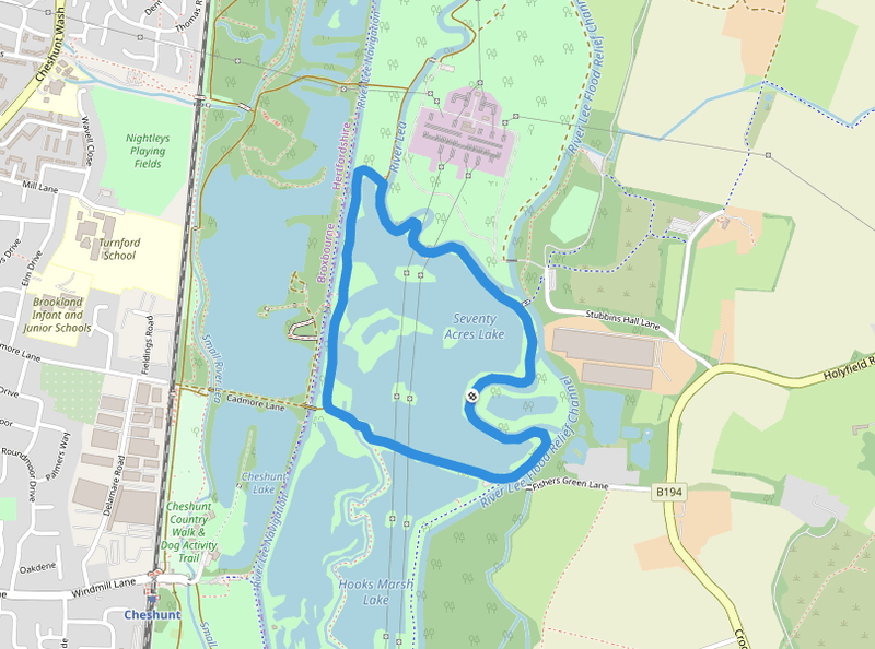
SEVENTY ACRES LAKE
As the name implies, a large lake of some 65 plus acres with islands, bays and varying depths. With an amazing food chain, it provides the perfect habitat for fish to grow large. With the vast amount of bank this water has, it’s not been put to the test in recent years. Many years ago, when commercials were unheard of, anglers fished in this neck of the woods with various Lee Valley pits, canals and rivers. In the summer, there would be many anglers fishing for the tench and bream and in the autumn and winter, perch and pike were the prey. Alas with the coming of the commercials, the banks became almost empty for many years, but now with many anglers moving back to natural waters, the next few seasons will put some unexpected fish on the bank which have been quietly growing.
Stocks consist of carp, bream, tench, perch and pike. There are also large shoals of roach and rudd.
The size of the carp and pike will be a surprise to many.


Cheshunt (/ˈtʃɛzənt/ CHEZ-ənt) is a town in the Borough of Broxbourne in Hertfordshire, England, 12 miles (19 km) north of Central London on the River Lea and Lee Navigation and directly south of Broxbourne. It contains a section of the Lee Valley Park, including much of the River Lee Country Park. To the north lies Broxbourne and Wormley, Waltham Abbey to the east, Waltham Cross and Enfield to the south, and Cuffley to the west.
Historically an ancient parish in the Hertford hundred of Hertfordshire, it was granted urban district status in 1894. Waltham Cross, which became a separate ecclesiastical parish in 1885, historically formed the southern part of Cheshunt, and remained part of the Cheshunt Urban District until its abolition in 1974. The urban districts of Cheshunt and Hoddesdon merged in 1974 to form the Borough of Broxbourne, the area's current local authority district. Cheshunt was not re-established as a successor parish.
At the 2011 census, Cheshunt had a population of 45,832.

Why no staying overnight in the area?

Walking from CHESHUNT to BROXBOURNE
The lock is located in the River Lee Country Park which is a part of the Lee Valley Park. The Seventy Acres Lake to the east is an important site for the bittern. [1] To the west is North Met Pit, a mature gravel pit of 58 acres divided into two. It is another former gravel pit which is popular with anglers and naturalists. [2]
The lock is located in the River Lee Country Park and is adjacent to the Old River Lea and the 180-acre (0.73 km2) Holyfield Lake which incorporates part of the River Lee Flood Relief Channel

HOLYFIELD LAKE

Home to Holyhead Fishery.

BROXBOURNE

HODDESDON

Create Your Own Website With Webador