

Walking and Cycling along the RIVER LEA VALLEY North of the QUEEN ELIZABETH II, the OLYMPIC PARK
WALTHAM ABBEY, to the East
The A12 is the high road that you are going to cross

CONTENT
Enjoy a Bucolic London…but do not forget that this was DICK TURPIN’s territory
HACKNEY MARSHES. Football & Cricket pitches
From filter beds to Natural Reserves. The Anglo-Saxons, and the “sexes”: a bit of history
LEA BRIDGE district
First Airfields and First Planes
The HENLEY of the LEA
SPRINGFIELD PARK
London sewage system
WALTHAMSTOW WETLANDS
Out of Greater London: ESSEX!
Inventions,Gun factories, and politics, by the LEA
Old Abbeys (thanks to Henry VIII): WALTHAM ABBEY
HACKNEY MARSHES

You are leaving behind the places at the centre of the big events of 2012. But, who remembers that?, you will say… Let’s look at the future!. And you are right. Precisely, on the way to and during the preparation for 2012 they were looking at the future and that future is NOW, and you are going to enjoy, as you know, the LEGACY of the OO/PPGG of 2012. That legacy is still being deployed and you are going to be witness of it!.
After the LEA VALLEY VELODROME and the VELOPARK
Alongside the ETON MANOR WALK
SUBSTATION
BRIDGE
Site of the ETON MANOR BOYS CLUB, now the HOCKEY and TENNIS CENTRE
BRIDGE
EAST MARSH
Now, again, a recreation ground, from 2010 became “OLYMPIC” land, anda huge parking lot was laid out here,o.
To your right
NEW SPITALFIELDS MARKET
The largest exotic fruits and veggies wholesale market in Europe. The successor of the OLD SPITALFIELDS MARKET that you have already visited and enjoyed, within the CITY OF LONDON, but, in reality, part of the EAST END.
The CITY CORPORATION decided to move the market here at the beginning of the 1980s, for logistical reasons, and that is why you see all over the place the CITY OF LONDON COAT OF ARMS. Do not be confused: you are in LEYTON, LB of NEWHAM


Keep walking straight on the ETON MANOR WALK, NWwards. Now, you are crossing the LEA river and entering the LB of HACKNEY.

Photo from HISTORY EXTRA

Do not get confused though
WHITE HOUSE BRIDGE
This section of the LEA once was a stocked fishery, and a delightful resort for holiday folk, back in the middle of the 19th.c. Lucky them, because a few decades before it used to be a haunt of highwaymen…
After WW2, the area was filled with rubble from bomb damage. Ups an downs… now you can see those beautiful playing fields.
Site of the WHITE HOUSE INN
It may have dated from the time of KING CHARLES III, and records suggest that this hostelry was set in the middle of wild marshlands, and had served as a hiding place for HIGHWAYMAN DICK TURPIN, Essex born (1706), who be ame apprentice with a butcher butcher in WHITECHAPEL, but, on the process, he began to steal sheep, lambs and cattle, a then becoming a member of an ESSEX GANG which raided the isolated houses of what we call now EAST LONDON. Well, not only… they robbed their way tge whole of the HOME COUNTIES, employing violent means of persuasion, like torture.
Old maps place the inn adjacent to a ferry, thus helping refresh the travellers to or from the HACKNEY and HOMERTON side.
You are leaving behind the
HACKNEY MARSHES SPORTS CENTRE

Photo from V&AMuseum
You have 2 options, after the BRIDGE:
FIRST OPTION.Now you will be walking alongside the West (HACKNEY) bank of the LEA, the North end wing of the MARKET will appear to your right. You are heading straight towards 2 NATURAL RESERVES, that use to be industrial sites.
When you will get to the FRIENDS BRIDGE, if you cross it, you will be entering the WATERWORKS NAT.RES.
if you do not you are heading to the MIDDLESEX FILTER BEDS NAT.RES.
SECOND OPTION: After the WHITE HOUSE BRIDGE the path takes you straight to the LEE NAVIGATION. You will walk along the towpaths, leaving behind the BRIDGE. The second bridge is the
COW BRIDGE
Cattle was once permitted to graze on the marshes for part of the year, under the ancient LAMMAS LAND grazing rights (see the CLAPTON PARK chapter of PART II). No football or cricket was practiced here, in the Middle Ages…
This is an inter-war period bridge, see the reinforced concrete, but it has recently widened and adapted for cars, cycles and pedestrians, thanks to the project of AMIN TAHA, architects, and WEBB YATES, engineers
On the other side, CLAPTON PARK. Remember the shops and eateries along CHATSWORTH ROAD and the SUNDAY market!
No more grazing, now…Football!

Looking for a grass football, rugby or cricket pitches in East London? Hackney Marshes, the spiritual home to grass roots football, has over 80 grass football, rugby and cricket pitches available for hire and bookings. As well as the sports pitches the Hackney Marshes Centre has 26 modern changing rooms, dedicated officials rooms, 3 fully equipped meeting/conference rooms, a large bar/function suite and free parking. Pitches are available for hire on a block booking or a pay as you play basis and are available to football/sports leagues or teams, local schools, community groups or individual bookers. We have: 58 adult grass pitches, 2 premium (step 7 standard) adult grass pitches, 14 junior pitches (5v5, 7v7 & 9v9), 3 Rugby pitches, 3 Grass Cricket pitches and 5 Artificial Cricket wickets. Discounted rates are available for midweek bookings – for more details email hackney.marshes@gll.org The Bar / Function suite can accommodate weddings, christenings, funeral wakes, private parties, birthdays or sports social events.
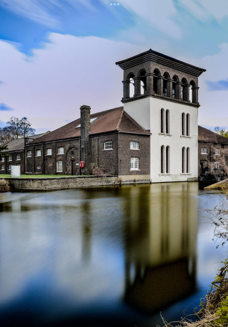
WATERWORKS & MIDDLESEX FILTER BEDS NATURE RESERVES
North of the LEA, the site of the WATERWORKS
South of the LEA, North of the LEA NAVIGATION, the site of the FILTER BEDS

Click this map and you will find more info
Crossing the FRIENDS BRIDGE …
FRIENDS BRIDGE
A fishery, associated with an INN, THE HORSE AND GROOM, occupied the site.
Arch. WHITBY & BIRD, with ART OF CHANGE. 1990
Now, enjoy the 2 Natural Reserves, at your own pace… Finally, you will be exiting the area alongside the West Bank of the Lea, after seeing NATURE’S THRONE, an artwork by local sculptor PAULA HAUGHNEY
From to WATERWORKS and WATERMILLS to FILTER BEDS to…


The LEA has played an important part in supplying water to London, from early 17th c., at least.
FRANCIS TYSSEN built the first LEA BRIDGE (or HACKNEY) WW c.1707, at JEREMY’S FERRY, N of LEA BRIDGE ROAD. By means of a waterwheel, water was brought out, then pumped and transported through wooden pipes to the CLAPTON RESERVOIR, from where it was distributed to the local people.
A very basic system, it eventually fell into disrepair and people had to go back to the old methods of water collection, that is, local pumps and rain butts.
In 1760 the HACKNEY WATERWORKS CO. set up, here where you are now, new waterworks. The site was bought, in 1829, by the EAST LONDON WATERWORKS CO. The area was becoming a manufacturing district…
Water, those times, was sold untreated. From the 1830s, these districts, already overcrowded and the people living in unsanitary conditions, several outbreaks of CHOLERA succeeded one after the other. 14.000 East Londoners dies in 1849. By 1855, 55.000 lives han been claimed, after a series of epidemics.
The ELWW Co. had to respond to the growing demand of water, and safer water became, as well, a general demand. In 1852 6 FILTER BEDS to purify water began to be built. Waterwheels, steam driven pumps, reservoirs… were, as well, important innovations.
By 1860, a growing understanding of how the disease was spread, coupled with a desire to improve the sanitation of the city led to these vast facilities being commissioned by Parliament. A vital supply of clean water was on its way.
In parallel, went the building of the London SEWAGE SYSTEM. Its creator: JOSEPH BAZALGETTE, a descendant of HUGUENOT refugees.
More sophisticated water treatment facilities, and pioneering scientific examination and testing were put in place here.
By the end of the 19th c. every house in London had water supply.
And here, by 1882 there were 25 FB in the ESSEX & MIDDLESEX WATERWORKS.
The METROPOLITAN WATER BOARD was founded in 1904.
Gradually water companies concentrated, and this installations went into decline, becoming finally obsolete and closing in 1972, when they were replaced by the new complex of COPPERMILL WATER TREATMENT PLANT, in WALTHAMSTOW.
How the FILTER BEDS worked?
Water, first of all, was taken out from further upriver, at WALTHAMSTOW, where it was cleaner, and stored in RESERVOIRS. Then, a AQUEDUCT carried the water (pipes under the LEA) and was pumped through a network of channels, so that the water tricked over the FB, where it was strained through layers of sand and gravel , eventually ending in a perforated concrete base, and along channels to a central culvert. This method is called SLOW SAND FILTRATION, with any foreign matter being collected in the top layer of sand and remains trapped there.
The resulting filtered water was bacteria free and could be pumped to homes all across NE London. The VICTORIA PUMP did the job.
2 large steam powered pumps were constructed to move the water: the DUKE and the DUCHESS, as they were nicknamed, have since been demolished.
A narrow gauge railway, running through the site, moved all materials: gravel, sand, clay pipes.
A NATURE RESERVE!
Now, put away your tablet. Everything is explained in the panels around the nature reserve. Enjoy!. However, if you are reading somewhere else, here are some notes I have taken…
The water treatment operation ceased in the 1970s. Human activity stopped . Wildlife moved back and new habitats developed over time. Some took hold quickly, others took many years to become what they are today.
The first few years, some FB were filled in and the main buildings demolished. And most of the site was left undisturbed, so that vegetation gradually took over along the fringes, habitats for birds and insects. BED still 18 looks similar to how it would have looked when the WW were still in use.
5 years on, the water level of BEDS 22,23 & 24 began to fall, tricking away or by evaporation: new islands of gravel and sand were exposed, a wet soil that became a perfect place for marshland plants, attracting insects, and then birds and amphibians. LITTLE COOT and RINGED PLOVER were the first birds to breed here.
10 years on, as more gravel/sand was exposed, the plant cover thickened and became denser. Marsh plants were thriving, the roots in the water, leaves and flowers growing above.
Insects attracted amphibians: FROGS, TODS, NEWTS.
Predators as GRAY HERON or GRASS SNAKE, found here a good hunting ground.
BEDS 17 and 17 managed to maintain a marshy wetland habitat.
25 years on… Much of the water had been drained away. A wet meadow, liable to flooding in times of high rainfall, would have developed. BED 14 replicates now a meadow condition, supporting plants adapted to them, as they like to be wet all through winter an come into flower when the summer warmth dries out the soil.
Much of the LEA VALLEY looked like this before the building of waterworks, mills and FB. Hay was cut around the 13 th of August, LAMMAS DAY. Afterwards, farmers were entitled to put their cattle to feed, which was called LAMMAS GRAZING
After 30 years, where FB were not managed in any way, WILLOW ASH and ALDER trees would eventually grow on them. Therefore, open water, reed beds and water meadows being shaded, would eventually dry out.
In fact, the LEA VALLEY was densely covered in woodland trees, before humans started cutting trees down and grazing their animals. A wonderful habitat for insects, birds and mammals, and an environment with a changing appearance from season ro season. BED 13 has been managed to allow trees to flourish.
An ECOLOGICAL SUCCESSION has taken place when an area has been turned from open water to woodland. This process has been observed thanks to the FB being managed and, thus, providing a range of successful habitats.
Every year, staff cuts vegetation back and control water levels in order to conserve each area, preventing them from turning to scrub and eventually to woodland.
A mosaic of habitats has been created, allowing a range of species like butterflies, dragonflies, reptiles, amphibians, and birds. That is BIODIVERSITY, that is, ECOLOGICAL SUCCESSION has been prevented of taken place.
A haven for nature and wildlife…
PANEL 1
The site began to be managed in order to provide a different range of habitats.
A carpet of COWSLIP covers the MEADOWS in Spring, becoming home to RINGLET BUTT, ROESEL’S BUSH crickets…and GRASS SNAKES are often seen hunting for frogs.
Here, in a remaining FB, you can contemplate a BIRD HIDE: a WARBLER nesting among reeds, a SNIPE feeding around muddy edges, a DUCK on open water, TEAL and SHOVETER, WOODPECKER and WARBLER (CHIFFCHAFF, WHITE THROAT) can be seen in wooden areas and scrub, KESTREL are hunting overhead.
MAMMALS: COMMON SHREW, WOOD MOUSE, VOLES, WEASELS… have found an excellent home in woodland scrub and grassland.
PANEL 2. OUR WILDLIFE GARDEN
PANEL 3. WILLOW VOODLAND
PANEL 4. WONDERFUL WILLOW WOODLAND
MILLING
HACKNEY MARSH was divided into ownership strips, in 1745.
Here, where the MFBNR is, the land was owned by MARGARET PROSSER, JOHN HARCOURT, FRANCIS TYSSEN and the DEAN & CHAPTER of ST.PAUL’S CATHEDRAL (LONDON). They were LAMMAS LAND, owner-cultivated from the 6th of April to the 12th of August, and the rest of the year a common cattle grazing.
A water channel or MILLRACE was dug out, which took the water from the river LEA to to the WATERWHEELS.
You will be standing over the SITE OF THE MILL RACE, almost all of which has been filled in.
There were here 3 types of mill: the ones pumping water, supplying up to 1000 families with water in only 12 hours; the ones grinding corn, to make flour; the ones powering the boring machines to make pipes out of trunks, pipes which served to carry water to the reservoir and, from there, to the local inhabitants. The pipes were made thinner at one end so they could slit together. Or powering the machines grinding the point to pins and needles (120.000 points a day), which were then polished here, after. Ring sent to WORCESTERSHIRE (REDDITCH) for the eyes to be made.
A disaster struck in 1796, when a fire broke out.
In 1829 the rebuilt mills were taken over by the ELWW Co. They were demolished and a new PUMP HOUSE was built, capable of pumping 13 millions barrels of water a year, to a reservoir in STAMFORD HILL.
When the millrace was cut, locks had to be built to maintain water levels, which caused a controversy between millers and bargemen. In 1766, JOHN SMEATON proposed a new waterway from LEA BRIDGE to OLD FORD, bypassing the mills. THOMAS YEOMAN, his assistant, directed the excavation. In 1769, the HACKNEY CUT, that is the LEE NAVIGATION, was opened.
This area constitutes a CONSERVATION AREA, within the LB of HACKNEY.
MIDDLESEX?, ESSEX?… plenty of “sex”!


The disappeared COUNTY OF MIDDLESEX used to “wrap” the CITY, in the M.A. When the CITIES of LONDON and WESTMINSTER were already an urban continuum, including the WEST END, during the 18th and 19th cs. MIDDLESEX continued to have a boundary with the new metropolis.
When the COUNTY OF LONDON was formed, the metropolis expanded and the COUNTY OF MIDDLESSEX was reduced in size.
When the modern GREATER LONDON was created, in 1965, the territories that used to be part of MIDDLESEX were absorbed. and the COUNTY was abolished.
To the East of the City, MIDDLESEX occupied the districts up to the RIVER LEA, until the creation of the COUNTY OF LONDON. Those districts conform the modern LB of TOWER HAMLETS.
To the East of the LEA it had always been the COUNTY OF ESSEX, until the GREATER LONDON area acquired the current districts up to the boundary with the modern ESSEX.

The 4 “sexes”

The expanding WESSEX kingdom
The ‘sex' in Essex, Wessex and Sussex is a corruption of ‘seaxe' which itself comes from the Old English ‘seaxan', meaning ‘saxon'.
So, Essex was the land of the East Saxons, Wessex was the land of the West Saxons and Sussex was the land of the South Saxons. There is a Middlesex - that's where the Middle Saxons were!
Expanding a bit on the other answers; there was no “Norsex” because there were no predominantly Saxon settlements north of the East Saxons, Middle Saxons and West Saxons. Essex, Middlesex and Wessex bordered East Anglia and Mercia, which were primarily Angle settlements. Angle settlements used the suffix “-folk.”
It is also said that Kent may have been a Geatish settlement and the Isle of Wight a Jutish settlement. There is also speculation that Geats and Jutes are closely related, if not the same.
Saxons, Angles, Jutes, Frisians, Geats?


If you exit the reserve onto LEA BRIDGE ROAD, you could be heading towards LEYTON

LEA BRIDGE DEPOT
A few listed buildings:
THAMES WATER warehouses and workshops
TURBINE HOUSE
PRINCE & PRINCESS SHED
TRIPLES BOILER SHED
ENGINEERS’ HOUSE (RED HOUSE)
Arts and crafts inspired, it provided offices
Alongside the LEA BRIDGE ROAD, further to the East:
Site of THE GREYHOUND PH.
Originally a beer shop established, here or close to this site, by John BRAITHWAITE, shortly before the STATION opened, in 1840.
The street level in front was raised, as a new road bridge over the tracks was b. in1843. The GF was opened to the new street level, with the old bar being converted into cellars.
In the 1920s JACK NOSEWORTHY created a motorcycle racing track behind, where CLAPTON ORIENT would play…
The pub was substantially reb. In 1946, finally closing in1997, becoming flats .
LEA BRIDGE RAILWAY STATION. EAST ANGLIA. trains to LIVERPOOL ST.STA.
Site of LEA BRIDGE GASWORKS
EAST LONDON BREWING COMPANY. LAMMAS ROAD
Site of MISSION SCHOOL
The district of LEYTON is now a stone throw, easily reachable on buses.
Back on route, within the MIDDLESSEX FILTER BEDS NATURE RESERVE. ARTWORKS!
As you are exiting the MIDDLESSEX FB NAT.RES. you will enjoy
MAGIC FISH by potter KATE MALONE and
NATURE’S THRONE by PAULA HAUGHNEY.
Alongside the RIVER LEA, and then alongside LEA BRIDGE ROAD
LEA BRIDGE ROAD & LEA BRIDGE
The only bridges crossing the LEA, until 1777, were the ones at BOW and at WALTHAM ABBEY.
The first bridge was built by order of an Act of Parliament. JEREMY’S FERRY, which had existed for time immemorial, was destroyed and other ferry was permitted here, within half a mile of the new bridge.
As the (timber) bridge had descended into poor conditions by 1821, it was replaced by a new, elegant iron structure, sadly replaced, at its turn, in 1897, y a more utilitarian one, but better able to cope with the increased demands made on it.
LEA BRIDGE DISTRICT (CONSERVATION AREA): you can link this route with HACKNEY & LOWER CLAPTON, in MILLFIELDS (ENJOY EAST LONDON).
The LEA BRIDGE district
THE PRINCESS OF WALES PH
Rebuilt in 1920, in a QUEEN’S ANNE REVIVAL, with ARTS & CRAFTS manners. The original features have been conserved
Site of THE SHIP AGROUND PH
Late 19th c. Stuccoed.The roof hidden by parapet.
No.142. Site of the CARBONIC GAS WORKS Subsequently, furniture works.
A glass bottle works was nearby, while here carbonated drinks were produced.
Was here where DR.JOHN PRIESTLEY, created the first man made, drinkable glass of sparkling water, in 1767. Remember, he lived in LOWER CLAPTON ROAD, HACKNEY, between 1792 and 94.
The buildings are linked, and were constructed in different periods, in a diversity of heights and shapes.
There is a front office block, where the main entrance is, plus an ornate brick side entrance, leading to an open courtyard. This one, contains traces of inset iron rails, on a radial pattern, for the trolleys and cranes or lifting machinery, to move goods around the works and, presumably, to load and unload goods from LEA BRIDGE DOCK.
There is a rear range of buildings, where an ornate GABLE (DUTCH SCROLL, pediment) faces the road. There is some terracotta detailing. And the chimney is handsome.
Alongside OTLEY TERRACE a taller building contained pumping (?) machinery or tanks for liquids. The window frames are made of cast iron or wrought iron.
Site of the FURNITURE WORKS.Buildings dating from 1935
Site of the SCHOOL HOUSE
B. c. 1860,,attributed either to the arch. E.C. HAKEWILL (Church of ST.JAMES THE GREAT, LOWER CLAPTON ROAD), or to RIBA Vicepresident ARTHUR ASHPITEL.
In an OS MAP of 1868 you can se it indicated as INFANTS’ SCHOOL.
Between 1894 and 1913 it became a MISSION ROOM. Afterwards it was used by various industrial purposes.
It looks that an entrance was used by the SCHOOLMASTER and girls. The N one, by boys.
TUDOR Gothic, in Kentish ragstone, laid to courses, with limestone dressings (corners, quoins, hoodmoulds).
Schoolroom and schoolmaster‘s house can be differentiated.
The schoolroom has a lower red clay tile pitched roof, a single hexagonal chimney to the S, and 3 windows with Tudor style hood moulds. The walls are retained by simple buttresses. To the N, trifoil high level windows.
A Tudor arched opening (on the 1975 N doors) forming a window head.
It is a single storey building, with 3 arched QUEEN POST TRUSSES, exposed purlins, in dark stained timber.
The fireplace has a BARONIAL style, the chimney piece having been lost.
2 doorways. The SE Tudor door leads to a passage, where originally was placed the children entrance and the coats area.
The SW square headed door, of later date, led to the schoolmaster’s house.
The SCHOOLMASTER’S HOUSE has a higher pitched roof, red clay with a stone bellcote (without a bell).
Four pot conjoined octagon chimney stack.
The W entrance has a Githic hood mould.
The Tudor style windows have hood moulds, stone transoms and mullions.
The GF contained kitchen and living rooms.
Chimney breasts and fireplaces were removed.
To the N, the playground area: a dwarf well, in Kentish, was once topped with a cast iron rail.
As Victorian polite society regarded canal workers as a problem group, adults most likely to frequent the pub, while children seldom attending school, the vocation of this school, run by the church, was instilling a bit of culture in those people.
From 1870 (FOSTER’S EDUCATION ACT), new state run schools were established.
With the decline of canal industries and transport, by the 1920s thus school was already considered old fashioned, and quaint.
By that time, it was used as mission room, church hall, Sunday school, before being sold to ECLIPSE GLASS WORKS. In the 60s, it was occupied by metal windows manufacturers (MAINTENANCE & CO.LTD.). By 1975, TESTIMONI & SONS, mechanical engineers (millwrights) were using it. In 2007 ceased to be used , becoming empty and neglected, until, after restoration, ring occupied by a VIETNAMESE BUDDHIST CONGREGATION
Nos 132 -140 OTLEY or RUSSELL TERRACE
Workers accommodation, of late 19th c. Similar to the block fronting the works.
A detailed, unified brick terrace, 3 storeys high, with the original sashes, plus a gauged brickwork. The rear elevation has been rebuilt.
The right hand GF might have been a shop (indicated by the white render at fascial level).
HILLSTOWE and LEAGRAVE STREETS
Terraced workers cottages
Again, your route continues up-river, on the HACKNEY side
LEA BRIDGE DOCK BRIDGE
1850s. Probably associated with a wider scheme: a new strong bridge over the CUT to the MILL, as new FB were being built.
The bridge ramparts formed the dock entrance.
PARADISE DOCK
Here was the entrance of the dock. It is not known if it was originally impounded by the entrance lock.
This dock was developed in the 1830s by WILL.HURST ASHPITEL.
Look at the bridge makers’ mark: “H & MD GRISSELL. LONDON 1853”
GRISSELL was a maker of POST-BOXES And COAL TAX POSTS, as well, at EAGLE WHARF ROAD, HOXTON.
What about a gate of the ROYAL EXCHANGE?.
RAILWAY VIADUCT, and bridge over the NAVIGATION. GREAT EASTERN RAILWAY COMPANY, CHINGFORD to LIVERPOOL ST. STA. LINE, erected in the 1860s and 70s. The line was supposed to reach HIGH BEECH, but the EPPING FOREST ACT, thwarted the project (and the forest was saved for the enjoyment of Londoners!).
An earlier line, gte first one in the area, opened in 1840, by the NORTH & EASTERN RWY, running up the valley itself, from BISHOPSGATE to BROXBOURNE. The LEA VALLEY LINE.
Those early steam railways led to the development of LEYTON and WALTHAMSTOW. The old were becoming suburbs of the metropolis.
LEA VALLEY PARK BRIDGE
If you walk the East side (towpath) of the NAVIGATION
LAMMAS LAND
Grazing++ Cattle++
An airport in the WALTHAMSTOW MARSHES?. Not yet, just an airfield, and for a while!


Here is where, in 1909, ALLIOT VERDON ROE, transferred his workshop, from the BROOKLANDS RACETRACK, near WEYBRIDGE, in SURREY. Precisely here, underneath the railway arch.
His first flying trials took place in 1907-1908.
He was an aircraft pioneer, who, in partnership with his brother, built THE BULLSEYE, a 9 HP JAP engined triplane.
In July 1908, after several failed starts, he succeeded in flying for about 100 feet over the marshes, becoming the FIRTS BRITON flying in ALL BRITISH powered plane. Here.
As they were evicted from here, they moved their “flights” to WEMBLEY. Afterwards, in 1910, ROE founded the AV ROE & Co., and moved where he found more space, MANCHESTER.
What became AVRO AIRCRAFT COMPANY went on to produce such famous machines as the LANCASTER and the VULCAN, and then the HAWKER SIDDELEY, which was in RAF service until 1984.
He was born in LANCASHIRE, in 1877. He did odd jobs in LANARK, where he intended to become surveyor. He started an apprenticeship in the railways, then he tried marine engineering, in the RN, but he was rejected. He persevered: dockyard jobs, engineer on board of SS JEBB (a Royal Mail ship between Britain and West Africa) and other vessels…
During those voyages, and observing the albatrosses’ soaring flight, he became interested in the possibility of developing a FLYING MACHINE.
In 1906 he applied for a job as Secretary of the ROYAL AERO CLUB, founded in 1901 by BUTLER , his daughter and HON. CHARLES ROLLS. The RAC,a t that time, did BALLONING demonstrations. ROLLS interview him, and thanks to his enthusiasm, he got the job.
In 1908 the WRIGHT BROTHERS demonstrated AIR FLYING in FRANCE, at HINAUDIÈRES racing track . Horse racing… now LE MANS occupies the site.
A short spell as a draughtman by GLO DAVIDSON, while a machine was being designed and built in DENVER, with SIR WILLIAM ARMSTRONG (ARMSTRONG & WHITWORTH manufacturers).
Back in Britain, he started designing flying models, winning the DAILY MAIL PRIZE in 1907, and with the prize money built his first full-size aeroplane, the ROE I BIPLANE, in his brother’s stables, in WEST HILL, PUTNEY, which he tested at BROOKLANDS, in 1908, his first successful flight. Then, because some managerial problems, moved up here, renting a couple of railway arches.
Now his AVROPLANE is in that SCIENCE MUSEUM, which you rarely miss when visiting London with kids… And why not visiting BROOKLANDS, where a replica is on display, beside many other items, not less a CONCORDE?.
He f. A.V.ROE AIRCRAFT COMPANY in. 1910, with his brother. Later it was renamed AVRO AIRCRAFT, based in GREAT ANCOATS ST., MANCHESTER. They sold 8.300+ units of his “504” model, mainly to the ROYAL FLYING CORPS, then to the RAF as training units.
In 1928, he sold shares and bought S.E. SAUNDERS, becoming SAUNDERS ROE (SARO), based in the ISLE OF WIGHT.
Later, it merged with WESTLAND AIRCRAFT.
An electronics division, hydrofoils, illuminated signs, the MARK 3 airborne boar and buses were part of the production
Flying boats, helicopters, hovercrafts (the FIRST modern one!), space crafts, military canoes, assault boats, load carriers… issued as well from their production lines
In 1929, A V ROE was knighted. In 1933, he changed his surname to VERDON-ROE, in homage to his mother. Along those years, he was a member of the BUF, a supporter of MOSLEY.
2 of his sons were killed in RAF action during WW2. Grandson BOBBY VERNON-ROE became a racing driver.
He lived in HAMBLE, HAMPSHIRE, until 1940.
Brother HUMPHREY was a businessman, an aircraft manufacturer, but, as well a philanthropists and Co-founder of the FIRST BIRTH CONTROL CLINIC, with MARY STOPES, his wife.


When you walk the West side of the NAVIGATION, you will realise that pubs must have been the focus of a thriving leisure resort, around this area, towards the end of the 19th c.: “THE HENLEY OF THE LEA”.
All turned around river boats: Building, repairing, hiring, storing… Many rowing clubs were based around here. The FIRST ALL WOMEN REGATTA took place here, in 1925!
A cluster of activities grew up, originally, around the HIGH HILL FERRY, which continued to operate until late 19th c.
Repetitive river flooding let to the clearance of residential properties on safety and higiene grounds, and only isolated fragments remain.
THE ANCHOR & HOPE PH
Early 20th c, but an earlier building stood here
Site of the ROBIN HOOD PH
Possibly included a hotel. Part of its gardens (it had a verandah and riverside terraces) survive as RH COMMUNITY GARDEN.
Former BEHIVE PH, now apartments. An earlier inn building was on site, though.
Want to remember all the pubs from BOW CREEK to the source of the LEA?
SPRINGFIELD PARK
On the map, I pinned down the SPRINGFIELD MARINA
253 and 254 From CLAPTON COMMON.
A beautifully landscaped park, opened in 1905. Designed by the CHIEF OFFICER of the LCC PARKS, the great Edwardian park designer JJ SEXBY.
The late Victorianos and the Edwardians envisioned a society enjoying nature, instead of pubs. A change of habits was needed, then, and they created pretty parks, indeed.
This one (14’7 ha, 36’4 acres), sloping down from the higher ground to the edge of the towpath, was formed on the site of 3 large houses and their grounds.
This is a designated NATURE RESERVE, in fact, a contact zone between London CLAY and BRICKEARTH, plus terraced GRAVELS. The springs and acid grassland here are unique. The hill was created by deposits of the ICE AGE.
The views across the LEA VALLEY and the WALTHAMSTOW MARSHES are awesome. That beautiful and valuable stretch of WETLANDS might be your next destination if you wan to discover a dragonfly sanctuary!.
Of course, you can decide to head to STAMFORD HILL and STOKE NEWINGTON, cycling/walking across the park (or up SPRING HILL) and the remnants of CLAPTON COMMON.
The archaeological findings here in the park have helped map out the process of human existence in HACKNEY. A PALEOLITHIC axe and flints were found to the S.
ROMAN artefacts (vessels, coffins, bones) were found during excavations in 1814 and 1847.
Later on, an ANGLO-SAXON CANOE, baptised as the SPRINGFIELD BOAT, unearthed during an excavation in the children’s play, has made historians that a ferry was in place here. A replica on display in the HACKNEY MUSEUM.
The surrounding area was used for some form of agriculture or husbandry. The park itself had meadows and hedgerows, used for cultivation.
WILSON’S HILL was left unploughed, even at war times, due to the steep slope, which make of it a difficulty terrain to cultivate.
The 3 villas built during the 18th and 19th cs had grounds covering much of the present park.
In modern times docks and factores surrounded the 3 villas that occupied the estate. Citation are common of calico ground, calico printers, milliners hanging fields, the New Tile Yard (the area where the BANDSTAND is now was very rich in clay)… GILES’S DOCK, a channel of water leading W from the LEA to SPRING LANE, used for loading barges, remained until 1868, and a varnish factory was beside it.
Near the main entrance of the park, on a road called SPRINGFIELD, stands the Georgian era SPRINGFIELD HOUSE. The land around it, went up for auction in 1902, and a group of local businessmen saved it from development, eventually falling into responsibility of the LCC. COLONEL SEXBY initiated the landscaping of those grounds. A pre-existent pond was enlarged, a tarmac car park was created to the East of the house (now a lawn), a circular band-stand, with a tiled roof and a shelter were erected. To the NE a triangular lawn lies where THE CHESTNUTS was.
SPRINGFIELD HOUSE, called, as well, SPRINGFIELD MANSION, THE MANSION, THE WHITE HOUSE, THE WHITE LODGE… is an early 19th c. Building. A drive lined with shrubbery and lawn, with circular beds, leads to a central Doric porch, with at its centre a four panelled door, and an elegant fanlight surmounting it. A bow window graces the NE garden front.
The SW corner of the Park derives from the gardens of the house, and now are little altered after being re-laid out in 1905.
The stables and a derelict glasshouse survived. And a restoration project began to be executed in 2019 (thanks to a grant from NAT.LOT.HERIT.FUND) in order to return the house to its original aspect, building new annexes for a kitchen and toilets, in order to use the income from the CAFÉ to mantain and improve the park. And the stables are now let out to businesses.
The glasshouse though has been replaced by a community events venue.
Parkland was improved: An island was created in the pond, a bowling green was added, and an extensive program of planting and landscaping was completed.
Two other large houses were on the estate but due to their deteriorating condition were demolished when the LCC took over: SPRINGHILL (which had been called TUDOR HOUSE, had been remodelled by SIR JOHN SOANE.was to the NW. and THE CHESTNUTS occupied much of the ground in the centre of the park
The 3 were built with brick earth extracted from the park. They had extensive gardens.
The former LODGE of the latter still stands, on the N perimeter of the park, midway down SPRING HILL, and it is now a private dwelling.
SPRING LANE, which ran through the estate had to be rerouted, and now is part of the TOWPATH walk, along the LEA. The LEA was straightened, and water channels dug out.
Can you the see emplacement of the 3 villas?

To the NE an area now included within the park, was GILES’S DOCK, which might have been associated with tile yards. Old maps show it (1774 estate map, 1868 OS map). In 1876 works to straighten the LEA might have caused to be filled in.
HORSESHOE BRIDGE
To the HORSEHOE THICKET and NORTH MARSH (E of the LEA NAVIGATION). 1894.
A new island was created, bypassing a meander of the natural LEA.
Here the COPPERMILL STREAM joints the river.
SPRINGFIELD MARINA
You will see narrow boats barges and house boats moored here, and, as well, boat repair, lifting machinery, workshop, chandlery (selling boat parts and accessories, tools, maps, fuel… And a galley or kitchen is provided, as well as safely recovery, and safety certificates. Enjoy East London at its most Picturesque!.
Up to 200 berths, for vessels cruising along the LEA, the STORT, and the THAMES from here.
Here you can divert towards WALTHAMSTOW. COPPERMILL LANE links with the HIGH STREET. You will leave behind the COPPERMILL LANE WATER TREATMENT WORKS.


On the map, I have pointed up LEUCHA ROAD, a listed conservation area. Beautiful houses.
Or… a little diversion


You can make some time to see and visit the OLD COPPERMILL or THE COPPERMILL TOWER.
From there, and Northwards, alongside the COPPERMILL STREAM, and between the WARWICK EAST RESERVOIR (West side) and the RESERVOIR NO.1, where the HERON ISLAND is (East side) you will get to the WALTHAMSTOW VISITOR CENTRE, at THE ENGINE HOUSE, where you can eat and drink, and, from there, to FERRY LANE and THE FERRY BOAT INN.
Alongside the LEA, after leaving behind the park, you are heading towards TOTTENHAM.
Look for bus 318
HIGH BRIDGE
The current, cambered steel bridge has succeeded the previous portal frame one, which, at its turn, replaced a wooden one.
The WALTHAMSTOW RESERVOIRS. In search of VIKINGS and HERONS

Here you have more information about the VIKINGS, as this area has a real association with them
Now you are following the natural course of the LEA, the WEST WARWICK RESERVOIR is on the East bank, and beside the EAST WARWICK, and all the reservoirs which are now part of the WALTHAMSTOW WETLANDS. Have a look at your phone, find your whereabouts, and enjoy this awesome place!.
The WALTHAMSTOW RESERVOIRS were built after their construction and that of filter beds were sanctioned by Act of Parliament, in 1853. The EAST LONDON WATERWORKS COMPANY became the sole supplier of water of the area.
The first reservoirs were constructed between FERRY LANE and COPPERMILL LANE in the 1860s. The commoners rights were purchased for £200 (LAMMAS LAND). During the excavations for the LOCKWOOD RESERVOIR a “VIKING SHIP BURIAL” was found.
In fact, it was a 17th c. boat, with no association at all with the rests of a body and a swordThis was the most celebrated discovery, it many other finds, dating from the STONE AGE to the SAXON AGE were made.
And now, these smaller, early reservoirs are a haven for a variety of wild birds, and the WALTHAMSTOW HERONRY is one of the largest in Europe.
Ideally your route continues on Northwards, alongside the LEA. You will be in MARKFIELD PARK in a matter of minutes… unless you decide to take a detour in order to cover your lunchtime needs: remember that you are walking an area very close to STAMFORD HILL and UPPER CLAPHAM where a large Jewish community live, so why not trying a KOSHER MEAL?. In GROVELANDS ROAD you are going to find the PARKSIDE KOSHER.
MARKFIELD PARK. THE MARKFIELD BEAM ENGINE AND MUSEUM


Now a visitor attraction, the BEAM ENGINE of the MARKFIELD ROAD PUMPING STATION was built , in 1886, in YORKSHIRE, having being transported here by barge. It was a 100 horsepower, finely decorated machine, with Doric columns and Acanthus leaves.
Its mission was pumping up to 4 million gallons of sewage water a day into the London sewage system, from TOTTENHAM to the BECKTON WORKS. it was operational until 1964, though from 1905 had been relegated to occasional duty for storm water pumping.
You are now in TOTTENHAM HALS, a WARD or district of the LONDON BOROUGH OF HARINGEY.
The VESTRY of the TOTTENHAM VILLAGE (more to the N) established a LOCAL HEALTH BOARD, following the passing of the 1848 PUBLIC HEALTH ACT, developing a communal system of water supply and drainage. By 1852, the BOARD had built a small sewage works, within the MARKFIELD HOUSE COUNTRY ESTATE. It was “a bright example” of such a service as CHADWICK and BAZALGETTE visited it…
As untreated sewage dissipated into the LEA, creating pollution and provoking cholera outbreaks, after public outcry and mounting pressure, public enquires… bans on river river disposal were put into effect and, between 1858 and 1882, were pioneered here experimental systems of sewage treatment.
1883-89. The local BOARD tendered for expanded sewage deposit and filtration tank facilities, a a new engine house and a bean pump: WOOD BROTHERS, a YORKSHIRE firm won the competition and the new treatment plant entered operation. Surface water and sewage from WOOD GREEN to TOTTENHAM would be discharged into the LEA, after treatment.
Between 1889 and 1905 the connection of the local sewerage with the NOS was effected, the effluent no longer being treated here,,but pumped to BECKTON.
With the continuous increase of population the pumping capacity had to be increased: extension works were open in 1905, with 3 new sets of steam driven pumps, and and engine house.
New sewage treatment works were built at EDMONTON, operational from 1906, made the works here redundant, and, except the 1888 BEAM ENGINE, all the infrastructure was removed.
From 1965 this place laid derelict, neglected, until a TRUST took responsibility for the engine, without many resources, though.
Finally, HARINGEY regenerated the park, restored the engine, and, in 2008, the MUSEUM opened to the public
To the N of MARKFIELD PARK
TOTTENHAM HALE
Timber has been unloaded in this area, from the LEA, for centuries. To hoist or to pull, or more precisely to “HALE”, that is how the action was called in OLD ENGLISH!.
Factories, factories, factories…
Chrysler dealers (Hale Motorso), car mats makers (Cannon Automotion), GESTETNER, duplicating machines (document reproduction predecessor), Eagle Pencils (later, Berol), envelope maker Millington (later, Dickinson), English Abrasives, HARRIS LEBUS, largest furniture maker in Europe, supplying the GLC… are some examples of what the area looked like around

If you need a bit of sustent, a drink or doing some shopping you are only minutes away from a retail park, and/or then, across FERRY LANE, you will find PRESSURE DROP BREWING and BEAVERTOWN BREWERY, side by side, where you can .

The FERRY BRIDGE
Until the 18th c. there were no road bridges over the LEA. All crossings were made by means of ferries.
Sir WILLIAM MAYNARD, LORD of the MANOR of WALTHAMSTOW TONI had a wooden TOLL bridge erected, in 1760. In the 1870s, with the sale of the property of the area, the ELWWCo acquired the right to collect the tolls. The CORPORATION abolished the toll when it purchased the rights, freeing the bridge.
The old bridge was replaced, in 1915, but the present iron structure, which was opened by the chairman of the ESSEX COUNTY COUNCIL, Mr.ANDREW JOHNSON.
The old County CREST of the 3 SAXON SEAXES can be seen.
THE FERRY BOAT INN
This was the house associated to the ferry that preceded the bridge. These houses often be ame ALEHOUSES or INNS, and nowadays this PH is a picturesque example, a Grade I Listed building.
It has from 17th to 18th c. parts.
On WHITSUN TUESDAY the MANOR COURT (WALTHAMSTOW TONI) was held here, until the 19th. .
Alongside FERRY ROAD you have an interesting diversion
Pointed on the map BLACKHORSE LANE. Keep reading…
You could be in LLOYDS PARK and the WILLIAM MORRIS GALLERY in a matter of minutes!. However, alongside BLACKHORSE LANE you will find a few MICRO-BREWERIES (remember the BEER-MILES), just in case!.
TOTTENHAM MARSHES, part of the WALTHAMSTOW WETLANDS. A new plant discovered… just to become extinct!

FA large area of open grass and scrub, straddling the LEA, at STONEBRIDGE LOCK, was where, in 1987, the WURZELL’S WORMWOOD, a strongly scented herb, whose flowers spring up from late October… a plant new to science (an European-Chinese hybrid) was discovered!. But, it is not here anymore…as it became extint!.
TOTTENHAM LOCK
This is one of the locks introduced to ensure consistent levels of water for navigation, when the LEE NAVIGATION was introduced in 1767.
2 branches of the LEA rejoin the NAVIGATION just S of the lock.
LO STATIONS: TOTTENHAM HALE and NORTHUMBERLAND PARK
To the W, another possible diversion… TOTTENHAM HOTSPURS STADIUM, BRUCE CASTLE MUSEUM and WOOD GREEN
BRUCE CASTLE MUSEUM, pointed out on the map is midway between the LEA and WOOD GREEN (remember the GREEN LANES’ TURKISH COMMUNITY?). Enlarge the map to see the STADIUM.
Along the HIGH ROAD, shops and eateries.
BANBURY RESERVOIR
The reservoir was completed by and for the East London Waterworks Company in 1903, and was subsequently taken over by the newly formed Metropolitan Water Board in 1904.[2]The reservoir is now owned by Thames Water. Literally from the WIKIPEDIA.
Like other locks as far as Ponder's End Lock it is large enough to take barges of up to 130 tons. The primary lock has been upgraded to mechanical operation, but the secondary lock is operated manually. WIKIPEDIA.
NORTH CIRCULAR ROAD
A now demolished VIADUCT, was constructed across the WALTHAMSTOW RESERVOIRS in 1929, it traversed the waterway by the. COOKS FERRY INN, one of the earliest crossing points of the river. The original ferry house did not survive, and neither its replacement, which was in turn swept away in the 1990s, when the road was widened
ANGEL ROAD SUPERSTORES
ANGEL ROAD LO STA.
On the East bank of the VALLEY
CHINGFORD MILL PUMPING STATION
On the site of a watermill (demolished, as was, as well, the miller’s house ) the ELWWCo built, in 1895, a pumping station added to a 200ft deep well, which penetrated through the London clay to the underlying chalk, producing water of exceptional purity.
Site of CHINGFORD HALL
Belonging to the MANOR OF CHINGFORD-ST.PAUL’S, as the DB recorded. The most was filled, the farm and other outbuildings, were demolished in 1940s, when the CORK CO. purchased it.
The last MANOR HOUSE (of the 1840s) survived until the 1970s, when it was replaced by the DE MANDEVILLE COURT.
DE MANDEVILLE, a powerful NORMAN LORD, took 10 acres of land from CHING.-ST.PAUL’S, as recorded in the DB, although he never was the LORD of the MANOR.
A PH and several place names reminds us of the HALL standing here.
OLD TOLL BRIDGE
As a result of the action taken by the CITY CORPORATION, in 1877, it was freed from payment of tolls. The “NOTICE TO DRIVERS OF LOCOMOTIVES” rusty sign still stands here, from c.1900
WILLIAM GIRLING RESERVOIR
Named in honour of the Chairman of the MWB.
Commenced in 1935, it was not completed until 1951, needing the obliteration of the natural course of the LEA. And on the site of the CHINGFORD AERODROME, established by the ROYAL NAVAL AIR SERVICE during WW1. It can hold up to 3.493 gallons.
It has been designed S of SSI, as it has become a refuge of wildfowl in Autumn and Winter
To the W EDMONTON GREEN LO STA.
PICKETT’S LOCK
LEA VALLEY ATHLETICS CENTRE
Herexwas the site of the 1973 Sports centre (with a National Athletics stadium), demolished in 2004. The initial plan, finally dropped, was to build a competition stadium to host the 2005 World Athletics Championship
Opened in 2007, it is and indoor and outdoor complex serving the SE of England. It is an elite venue, at the service cutting edge of sports science andcphysiotherapy, but as well open to the public.
The 2014 INVICTUS GAMES were held here.
LEA VALLEY GOLF COURSE
LEA VALLEY CAMPING & CARAVAN PARK
PONDERS END LAKE


Pointed out on the MAP, SOUTHBURY LO
Buses to CHINGFORD
CHINGFORD LO STATION
To WALTHAM ABBEY

Bus 491


Welcome to the COUNTY OF ESSEX
Welcome to EPPING FOREST DISTRICT!.
Districts of Essex: the County council run area is in pink. 13 and 14 are unitary authorities, running its own affairs. You are in 6, EPPING FOREST


GUNPOWDER COUNTRY PARK

Another reminder of Waltham Abbey’s ‘explosive’ past, Gunpowder Park was formerly a ROYAL ORDNANCE site concerned with munitions testing. Now given over to wildlife, features of the original landscape have been retained and the entrance and graphics evoke its former life and the area’s connection with the manufacture of gunpowder and explosives. The park has been given a Green Flag Award.
As well as open space for recreation, outdoor pursuits, arts and entertainment, the park has fields, meadow and marsh to be enjoyed by walkers and cyclists throughout the year and horse riders on the permissive bridleway in the summer.

Remember that further down the river at THREE MILLS, near BROMLEY BY BOW, NICHOLSON’s (of CLERKENWELL) had established a Gin Distillery?. Thanks to the import of grain down the LEA. It was there that a JEWISH immigrant by the name of CHAIM WEIZMANN, made a vital contribution to the First World War effort. He came up with a method of turning GRAIN into ACETONE which was crucial to the manufacture of cordite explosive propellants.
Having produced 30,000 tonnes of acetone to support the war effort, at Nicholson's and other factories around the country, Weizmann, who was a key Jewish ACTIVIST at the time, was courted by well-known and respected figures such as BALFOUR, LLOYD GRORGE and CHURCHILL.
Although he constantly refused honours for his war work, he did make the case for a HOMELAND for his people. By 1948, he had been sworn in as the FIRST President of Israel. So it's not too far a stretch to say that the origins of the State of Israel lie by the RIVER LEA!.
M25

WALTHAM ABBEY
Waltham Abbey is a unique and traditional market town full of character and charm and surrounded by heritage including 16th century timber-framed buildings and a fine 'Art Nouveau' Town Hall. It has impressive associations with Royalty including King Harold, Henry II and Henry VIII. Its charter as a market town was granted by Richard the Lionheart in 1189 and the impressive Waltham Abbey Church and gardens remains as a reminder of the monastic centre that once dominated the town, founded by King Harold in 1060. King Harold was reputedly buried in the grounds following his death at the Battle of Hastings in 1066. The town centre is also home to the Epping Forest District Museum which has recently reopened after a major refurbishment and extension to its Grade II* listed Tudor building to improve facilities, displays and exhibition space.
Gunpowder was produced here and shipped to WOOLWICH.
The thick walls were able to contain the blasts when explosives were tested.
In 1991 this research and production facility closed, after more than 4 centuries in operation.
Create Your Own Website With Webador